


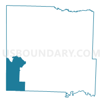
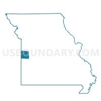
Hume Voting District, Bates County, Missouri
About
Outline

Summary
| Unique Area Identifier | 607099 |
| Name | Hume Voting District |
| County | Bates County |
| State | Missouri |
| Area (square miles) | 58.31 |
| Land Area (square miles) | 56.69 |
| Water Area (square miles) | 1.62 |
| % of Land Area | 97.22 |
| % of Water Area | 2.78 |
| Latitude of the Internal Point | 38.13629480 |
| Longtitude of the Internal Point | -94.56359690 |
Maps

Graphs
Select a template below for downloading or customizing gragh for Hume Voting District, Bates County, Missouri


Neighbors
Neighoring Voting District (by Name) Neighboring Voting District on the Map
- Amoret Voting District, Bates County, MO
- Butler No. 3 Voting District, Bates County, MO
- North Potosi Voting District, Linn County, KS
- Rich Hill South Voting District, Bates County, MO
- Rinehart Christian Church Voting District, Vernon County, MO
- Sheridan Township Voting District, Linn County, KS
- South Potosi Voting District, Linn County, KS
- Valley Township Voting District, Linn County, KS
Top 10 Neighboring County Subdivision (by Population) Neighboring County Subdivision on the Map
- Potosi township, Linn County, KS (1,840)
- Howard township, Bates County, MO (554)
- Sheridan township, Linn County, KS (527)
- Homer township, Bates County, MO (447)
- Walnut township, Bates County, MO (394)
- Metz township, Vernon County, MO (374)
- New Home township, Bates County, MO (245)
- Henry township, Vernon County, MO (231)
- Valley township, Linn County, KS (147)
Top 10 Neighboring Place (by Population) Neighboring Place on the Map
Top 10 Neighboring Unified School District (by Population) Neighboring Unified School District on the Map
- Nevada R-V School District, MO (15,264)
- Butler R-V School District, MO (6,338)
- Jayhawk Unified School District 346, KS (3,376)
- Rich Hill R-IV School District, MO (2,572)
- Pleasanton Unified School District 344, KS (1,990)
- Miami R-I School District, MO (1,457)
- Hume R-VIII School District, MO (834)
Top 10 Neighboring State Legislative District Lower Chamber (by Population) Neighboring State Legislative District Lower Chamber on the Map
Top 10 Neighboring State Legislative District Upper Chamber (by Population) Neighboring State Legislative District Upper Chamber on the Map
Top 10 Neighboring 111th Congressional District (by Population) Neighboring 111th Congressional District on the Map
Top 10 Neighboring Census Tract (by Population) Neighboring Census Tract on the Map
- Census Tract 9551, Linn County, KS (5,353)
- Census Tract 702, Bates County, MO (4,411)
- Census Tract 9552, Linn County, KS (4,303)
- Census Tract 9502, Vernon County, MO (2,215)
Top 10 Neighboring 5-Digit ZIP Code Tabulation Area (by Population) Neighboring 5-Digit ZIP Code Tabulation Area on the Map
- 64730, MO (7,109)
- 64779, MO (2,693)
- 66075, KS (2,103)
- 64752, MO (735)
- 64722, MO (525)
- 66767, KS (511)